


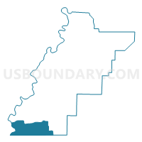
Fayettville -Co Line, Talladega County, Alabama
About
Outline

Summary
| Unique Area Identifier | 522944 |
| Name | Fayettville -Co Line |
| County | Talladega County |
| State | Alabama |
| Area (square miles) | 50.32 |
| Land Area (square miles) | 47.56 |
| Water Area (square miles) | 2.75 |
| % of Land Area | 94.53 |
| % of Water Area | 5.47 |
| Latitude of the Internal Point | 33.12735760 |
| Longtitude of the Internal Point | -86.36750450 |
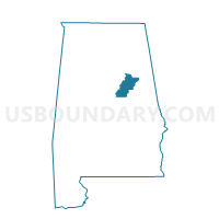
Maps

Graphs
Select a template below for downloading or customizing gragh for Fayettville -Co Line, Talladega County, Alabama


Neighbors
Neighoring Voting District (by Name) Neighboring Voting District on the Map
- Bay Springs Baptist Church, Shelby County, AL
- Craig Smith Comm Center, Talladega County, AL
- Lay Lake Vol Fire-St. Andrew's Church, Talladega County, AL
- Limbaugh Comm Center-Bon Air- Oak Grove, Talladega County, AL
- Old Shelby Elementary School, Shelby County, AL
- Pct. 1117 Weogufka Voting House, Coosa County, AL
- Pct. 1216 West Coosa Senior Center, Coosa County, AL
- Pct. 1318 Marble Valley Fire Dept., Coosa County, AL
Top 10 Neighboring County Subdivision (by Population) Neighboring County Subdivision on the Map
- Sylacauga CCD, Talladega County, AL (22,123)
- Columbiana CCD, Shelby County, AL (12,123)
- Weogufka-Marble Valley CCD, Coosa County, AL (3,927)
Top 10 Neighboring Place (by Population) Neighboring Place on the Map
- Sylacauga city, AL (12,749)
- Stewartville CDP, AL (1,767)
- Fayetteville CDP, AL (1,284)
- Talladega Springs town, AL (166)
Top 10 Neighboring Unified School District (by Population) Neighboring Unified School District on the Map
- Shelby County School District, AL (170,473)
- Talladega County School District, AL (49,716)
- Sylacauga City School District, AL (12,749)
- Coosa County School District, AL (11,539)
Top 10 Neighboring State Legislative District Lower Chamber (by Population) Neighboring State Legislative District Lower Chamber on the Map
Top 10 Neighboring State Legislative District Upper Chamber (by Population) Neighboring State Legislative District Upper Chamber on the Map
Top 10 Neighboring 111th Congressional District (by Population) Neighboring 111th Congressional District on the Map
Top 10 Neighboring Census Tract (by Population) Neighboring Census Tract on the Map
- Census Tract 115, Talladega County, AL (5,591)
- Census Tract 116, Talladega County, AL (4,857)
- Census Tract 9611, Coosa County, AL (3,927)
- Census Tract 307.04, Shelby County, AL (3,874)
- Census Tract 119, Talladega County, AL (2,948)
Top 10 Neighboring 5-Digit ZIP Code Tabulation Area (by Population) Neighboring 5-Digit ZIP Code Tabulation Area on the Map
- 35150, AL (18,472)
- 35051, AL (8,787)
- 35044, AL (7,713)
- 35151, AL (7,632)
- 35143, AL (3,281)
- 35183, AL (706)